
Hide
Maryton
hide
Hide
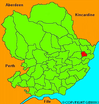
"Situate don the south bank fo the river South Esk, which here forms the bason of Montrose. It contains about 3000 acres, divided into two estates, viz Old Montrose and Dysart, belonging to Sir David Carnegie, and Mr Carnegie of Craigo. The latter estate is considerably higher than the former; but except the bank, which is the boundary between them, the ground is in general very level. The soil, on the low ground, is a rich clay, and the higher grounds have a fine loam, both of which are exceedingly fertile."
The Gazetteer of Scotland, W Chalmers, Dundee 1803.
Hide
| Maryton Church, Maryton, Church of Scotland |
| Maryton Church, Maryton, Church of Scotland |
- The transcription of the section for Maryton from the National Gazetteer (1868) provided by Colin Hinson.
- Ask for a calculation of the distance from Maryton to another place.
You can see maps centred on OS grid reference NO669562 (Lat/Lon: 56.696769, -2.54277), Maryton which are provided by:
- OpenStreetMap
- Google Maps
- StreetMap (Current Ordnance Survey maps)
- Bing (was Multimap)
- Old Maps Online
- National Library of Scotland (Old Ordnance Survey maps)
- Vision of Britain (Click "Historical units & statistics" for administrative areas.)
- Magic (Geographic information) (Click + on map if it doesn't show)
- GeoHack (Links to on-line maps and location specific services.)
- All places within the same township/parish shown on an Openstreetmap map.
- Nearby townships/parishes shown on an Openstreetmap map.
- Nearby places shown on an Openstreetmap map.