
Hide
Gartly
hide
Hide
hide
Hide
Hide
Hide
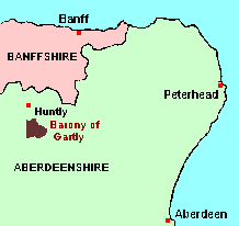
The parish of Gartly is nowadays reckoned as belonging to Aberdeenshire, and the main article about it will therefore be found among the GENUKI Aberdeenshire pages. However, before the major re-alignment of parish and county boundaries which came into effect on 1st May 1891, the parish belonged in part to Banffshire. The remaining articles on this page give details.
Hide
- Ask for a calculation of the distance from Gartly to another place.
Until 1st May 1891, the "Barony of Gartly", that part of the parish which lay to the east of the River Bogie (that is, furthest away from the Banffshire "mainland"), was deemed to be part of Banffshire. Writing in the "New Statistical Account" in 1836, the minister of the parish states that: "This anomaly is said to have arisen from the circumstance that the proprietor of the barony, Baron Barclay, one of the feudal barons of the ancient Earls of Huntly, being Sheriff of the County of Banff, used means to get his domains within his own jurisdiction."
Whatever the origin of the oddity, it is not likely to have any great consequences for genealogy. OPRs, the civil Registers of Births, Deaths and Marriages, and the Census treat Gartly as belonging exclusively to Aberdeenshire. It may be, however, that taxes on land and transfers of land are recorded under Banffshire.
You can see maps centred on OS grid reference NJ523325 (Lat/Lon: 57.380426, -2.79496), Gartly which are provided by:
- OpenStreetMap
- Google Maps
- StreetMap (Current Ordnance Survey maps)
- Bing (was Multimap)
- Old Maps Online
- National Library of Scotland (Old Ordnance Survey maps)
- Vision of Britain (Click "Historical units & statistics" for administrative areas.)
- Magic (Geographic information) (Click + on map if it doesn't show)
- GeoHack (Links to on-line maps and location specific services.)
- All places within the same township/parish shown on an Openstreetmap map.
- Nearby townships/parishes shown on an Openstreetmap map.
- Nearby places shown on an Openstreetmap map.
Locations concerned in the transfer are: Backburn, Birkenhill, Bothwellseat, Burnside, Cockstown, Coldwells, Corncatterach, Corskie, Corskiehill, Duncanstown, Faichhill, Gartly Station, Gartly Church, Gartly Manse, Gartly School, Mains of Gartly, Mill Croft of Gartly, Gimpstone, Glennieston, Kirkhill, Kirkstyle, Melsach, Millhill, Easter Mosshead, Wester Mosshead, Risquehouse, School Croft, Shanquhar, Stodfold, Mains of Stodfold, Westseat, Willshach, Woodlands.
You can also see Family History Societies covering the nearby area, plotted on a map. This facility is being developed, and is awaiting societies to enter information about the places they cover.