
Hide
Lisvane
hide
Hide
hide
Hide
hide
Hide
Hide
"LISVANE (LLYS-VAEN), a parish in the hundred of KIBBOR, county of GLAMORGAN, SOUTH WALES, 5 miles (N. by E.) from Cardiff, containing 253 inhabitants. It is situated on the western bank of the Romney, which here separates the counties of Glamorgan and Monmouth. The living is a perpetual curacy, in the archdeaconry and diocese of Llandaf, endowed with £ 1000 royal bounty, and £200 parliamentary grant, and in the patronage of the Earl of Plymouth, and C. K. Kemeys Tynte, Esq., alternately. The church, dedicated to St. Denis, is a small structure. Mary Lewis, by deed in 1728, gave a rent-charge of £23 for teaching and apprenticing poor children of the parishes of Lisvane and Llanishen : there is also a small endowment of £ 1.15. per annum for distribution among the poor not receiving parochial relief. The average annual expenditure for the maintenance of the poor is £ 131." ( A Topographical Dictionary of Wales by Samuel Lewis 1833).
Hide
Here is a substantial reading list of books which relate to Glamorgan, either county or parish.
The Glamorgan Family History Society have produced a set of microfiche containing Monumental Inscriptions for the following burial grounds :-
- Parish Church of St. Denys
- Baptist Church
| St Denys, Lisvane |
| Fairoak Baptist Chapel, Lisvane |
Chapels Database - a list of all known non-conformist chapels or other non-Anglican religions in the parish
For full and up-to-date details of their holdings see the sites of Glamorgan Record Office and/or West Glamorgan Archives
See Bap/Mar/Bur data on FreeReg
The church is dedicated to St. Denys and is in the Benefice of Lisvane. Details of the present incumbent of this benefice can be found at the Church in Wales website. The church can be located at grid reference ST192831.
A transcription of the registers is available from the Glamorgan Family History Society for the years: Baptisms, 1724-1902, Marriages, 1724-1838, Burials, 1724-1902. Visit their website for information on how to purchase these fiche.
| Anglican Parish Registers Held at the Glamorgan Record Office, Cardiff | ||||
| Baptisms | Marriages | Burials | Banns | Bishops Transcripts |
| 1760-1810, 1813-1822, 1862-1980 | 1755-1811, 1813-1861 | 1760-1992 | - | 1724-1725, 1777-1821. 1823-1827, 1829-1830, 1832-1837 |
Details of extant records on Archives Network Wales for the following;
- Lisvane Ecclesiastical Parish records " ........ including registers of baptisms, 1760-1980; burials, 1760-1992; marriages, 1755-1861; churchwardens accounts, 1765-1768"
The following Religious Institutions are covered in the Mormon International Genealogical Index (IGI) :-
- Lisvane (Llysfaen), St. Denys - Christenings (BT's), 1724-1875
Transcript of complete name listing for Whitchurch, with the parishes and villages of Lisvane, Llanishen, Pentyrch, Tongwynlais, Taff's Well and Walnut Tree Bridge, from Slaters Directory for 1880.
The transcription of the section for Lisvane from The National Gazetteer (1868) provided by Colin Hinson.
- Ask for a calculation of the distance from Lisvane to another place.
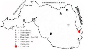
This diagram shows the position of this parish within the county of Glamorgan - click on this to see a full size diagram of the county
|
Parish map (Kain/Oliver)
You can see maps centred on OS grid reference ST191837 (Lat/Lon: 51.545959, -3.167839), Lisvane which are provided by:
- OpenStreetMap
- Google Maps
- StreetMap (Current Ordnance Survey maps)
- OpenStreetMap Cymru (Welsh counties only)
- Bing (was Multimap)
- Old Maps Online
- National Library of Scotland (Old Ordnance Survey maps)
- Vision of Britain (Click "Historical units & statistics" for administrative areas.)
- Magic (Geographic information) (Click + on map if it doesn't show)
- GeoHack (Links to on-line maps and location specific services.)
- All places within the same township/parish shown on an Openstreetmap map.
- Nearby townships/parishes shown on an Openstreetmap map.
- Nearby places shown on an Openstreetmap map.
Places, villages, farms etc within Lisvane as shown on the online parish map from the CD of Historic Parishes of England and Wales: an Electronic Map of Boundaries before 1850 with a Gazetteer and Metadata [computer file]. (Kain, R.J.P., Oliver, R.R.). (Extracted by Gareth Hicks)
- Lisvane (136); Brooklea ?; Church House Fm.; Fair; Lisvane (village); Tai-mawr; Ty-mawr;
The Population of Lisvane was as follows, and a more detailed breakdown is available.
| 1841 - 207 | 1851 - 220 | 1861 - 226 | 1871 - 242 | 1881 - 228 | 1891 - 248 |
Details of extant records on Archives Network Wales for the following;
- Lisvane Civil Parish records " .... including vestry minutes book, 1868-1880; parish meeting/council minutes book, 1894-1974; receipt and payment books, 1921-1967; assistant overseers rate books, 1851-1926; assistant overseers' receipt, payment and collector bboks, 1867-1926; highway surveyors rate books, 1864-1882; highway surveyors accounts book, 1865-1879; parish meeting account book, 1897-1914; income tax collectors' duplicates, 1867-1868; copy of tithe plan and apportionment, 1845"