
Hide
Monknash
hide
Hide
hide
Hide
hide
Hide
Hide
"MONK NASH, or, GREAT NASH, in the Cwmwd of Maenor Glynn Ogwr, Cantref of Cron Nedd (now called the Hundred of Ogmore), County of GLAMORGAN, South Wales: a Curacy, not in charge, of the certified value of £15: Patron, The Hon. William Booth Grey, in right of his 'Wife Miss Price, an Heiress. The Resident Population of this Parish, in 1801, (including the Hamlet of Broughton) was 101. The Money raised by the Parish Rates, in 1803, was £46..10..0, at 7s 3d. in the pound. It is 6 1/2 m. S.W. from Cowbridge. This Parish contains 1250 acres of Land, all inclosed and cultivated: and is bounded by the Bristol Channel. According to the Diocesan Report, in 1809, the yearly value of this Benefice, arising From Composition for Tythes, and Augmentation, was £48. " From: A Topographical Dictionary of The Dominion of Wales by Nicholas Carlisle, London, 1811.
"MONKNASH (MONK-NASH), a parish in the hundred of OGMORE, county of GLAMORGAN, SOUTH WALES, 7 miles (W. S. W.) from Cowbridge, containing 121 inhabitants. This manor, together with the castle and lordship of Neath, was given by FitzHamon to Sir Richard de Grenville, and by him conferred on the monks of Neath abbey, from which circumstance it has derived the prefix to its name. The parish is situated on the shore of the Bristol channel the coast is extremely dangerous for some miles between it and Barry. The Nash sands are a perilous ridge, covered at high water, but exposed at low water, on which the Frolic steam vessel from Tenby to Bristol, laden with passengers, struck, in the month of March, 1831, the weather being exceedingly tempestuous and hazy, when all on board perished : recently two lighthouses have been erected near them, which serve to warn navigators of the danger, as they stretch several miles westward from the coast, and the sounding immediately contiguous is four fathoms. The living is a perpetual curacy, in the archdeaconry and diocese of Llandaf, endowed with £200 royal bounty, and £200 parliamentary grant, and in the patronage of the Hon. William Booth Grey. The church is dedicated to St. Mary. The average annual expenditure for the support of the poor is £36. 11."( A Topographical Dictionary of Wales by Samuel Lewis 1833)
Hide
Here is a substantial reading list of books which relate to Glamorgan, either county or parish.
The Glamorgan Family History Society have produced a set of microfiche containing Monumental Inscriptions for the following burial grounds :-
- Parish Church of St. Mary Magdalene
| St Mary, Monknash |
| Cwm Nash Burial Ground, Cwm Nash? |
Glamorgan Chapels Database - no non-conformist chapels found in this parish
For full and up-to-date details of their holdings see the sites of Glamorgan Record Office and/or West Glamorgan Archives
See Bap/Mar/Bur data on FreeReg
The church is dedicated to St. Mary, and is in the Benefice of Llantwit Major. Details of the present incumbent of this benefice can be found at the Church in Wales website. The church can be located at grid reference SS919707.
A transcription of the registers is available from the Glamorgan Family History Society for the years: Baptisms, 1721-1987, Marriages, 1721-1837, Burials, 1721-1987.
| Anglican Parish Registers Held at the Glamorgan Record Office, Cardiff | ||||
| Baptisms | Marriages | Burials | Banns | Bishops Transcripts |
| 1813-1987 | 1754-1969 | 1813-1987 | - | 1721, 1723-1727, 1730-1737, 1739-1740, 1743, 1745, 1747-1748, 1750-1820, 1822-1837 |
Details of extant records on Archives Network Wales for the following;
- Ecclesiastical Parish records "........... including registers of marriages, 1754-1987; baptisms, 1813-1987; burials, 1813-1987; services, 1925-1961"
The following Religious Institutions are covered in the Mormon International Genealogical Index (IGI) :-
- Monknash, St. Mary - Christenings (BT's), 1812-1873
Conservation areas within the Vale of Glamorgan. See Monknash - "Conservation areas are areas of special architectural or historic interest, the character or appearance of which it is desirable to preserve or enhance"
Various landscapes - on the People's Collection Wales site
Transcript of complete name listing for Wick, with the parishes and villages of Llandow, Marcross and Monknash, from Slaters Directory for 1880.
The transcription of the section for Monknash from The National Gazetteer (1868) provided by Colin Hinson.
- Ask for a calculation of the distance from Monknash to another place.
Details of extant records on Archives Network Wales for the following;
- Bruce family of Monknash records 1728-1972 "John Bruce Knight of Dyffryn, Aberdare (afterwards John Bruce Pryce) inherited the Monknash estate in 1837 under the will of his distant cousin Mrs Booth Grey of Dyffryn, St Nicholas. By the early twentieth century, the estate consisted of over 1,400 acres in the parishes of Monknash, Marcross and Llandow; and also a Western or Neath estate in Cadoxton-juxta-Neath, Michaelston Higher, Pontrhydyfen and Rhos, Pontardawe (which included mineral rights). The main family house was Blaen-y-cwm in Monknash"
Some of the hamlets, towns and villages within this parish
- Broughton (Now in the Parish of Wick)
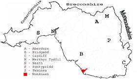
This diagram shows the position of this parish within the county of Glamorgan - click on this to see a full size diagram of the county
|
Monknash parish, Glamorganshire - on the People's Collection Wales site
Parish map (Kain/Oliver)
You can see maps centred on OS grid reference SS921701 (Lat/Lon: 51.419762, -3.553348), Monknash which are provided by:
- OpenStreetMap
- Google Maps
- StreetMap (Current Ordnance Survey maps)
- OpenStreetMap Cymru (Welsh counties only)
- Bing (was Multimap)
- Old Maps Online
- National Library of Scotland (Old Ordnance Survey maps)
- Vision of Britain (Click "Historical units & statistics" for administrative areas.)
- Magic (Geographic information) (Click + on map if it doesn't show)
- GeoHack (Links to on-line maps and location specific services.)
- All places within the same township/parish shown on an Openstreetmap map.
- Nearby townships/parishes shown on an Openstreetmap map.
- Nearby places shown on an Openstreetmap map.
Places, villages, farms etc within Monknash as shown on the online parish map from the CD of Historic Parishes of England and Wales: an Electronic Map of Boundaries before 1850 with a Gazetteer and Metadata [computer file]. (Kain, R.J.P., Oliver, R.R.). (Extracted by Gareth Hicks)
- Monknash (162); Blaen-y-cwm; Camp; Church (site of); Clawdd y Mynach; Craig Beiri; Cwm Bach; Cwm Nash; Monastery (remains of); Monknash (village); Monkton East; Monkton Ganol; Old Windmill; Pen-y-cae; Traeth Mawr; Ty'n-y-caeau.
There are many references to this area in the 15 million Welsh and English language articles from Welsh newspapers transcribed by the NLW and viewable on Welsh Newspapers Online
Below are English language articles that have been re-transcribed and extracted randomly to illustrate what is available, there are many that are not extracted here that include names of local people
- From The Western Mail 24th October 1871
WRECK OF A STEAMER AT MONKNASH. The screw steamer Phoenix, bound with coal from Porthcawl to Bristol, sprung a leak on Saturday last and the captain was compelled to run her on shore at Monknash, where she now lies, a complete wreck. She belongs to Mr Payne of the Vauxhall Ironworks, Bristol, and is uninsured
- From the Evening Express (Pink Edition) 21st November 1895
AT MONKNASH A SERVANT GIRL MEETS WITH A TRAGIC END. A pitiful story comes from Monknash of the sad death cf a young girl, named *, whose parents reside at Abergavenny. It appears that she had not found her place as servant at Monckton Farm to her liking and had written home on the matter. Her mother, however, had advised her to stop her twelve month out, and promised her a present. On Sunday night the girl went to chapel and singing school, and afterwards with a walk with a companion. She left her girl companion about 9.30, and shortly after was seen going in the direction of the sea by a young man. She did not return to her service, and on Tuesday morning her dead body was discovered by a couple of "laver bread" weed gatherers, one leg and one arm being broken. The body was taken to the Plough and Harrow at Monknash, where an inquest was held on Wednesday evening by Mr. T. Stockwood, coroner for the manor of Ogmore, when an open verdict was returned.
- From the Evening Express (Extra Football) 6th March 1897
Glamorgan Council - Dr. Williams, the medical officer for the county, reported that an outbreak of anthrax had occurred in several districts, including Monknash, and he recommended that in future carcases should be cremated instead of buried.
The Population of Monknash was as follows, and a more detailed breakdown is available.
| 1841 - 109 | 1851 - 110 | 1861 - 121 | 1871 - 103 | 1881 - 78 | 1891 - 90 |
Details of extant records on Archives Network Wales for the following;
- Monknash Civil Parish records " .......... comprising copy of tithe plan and apportionment, c. 1840, [copied 1980]."